
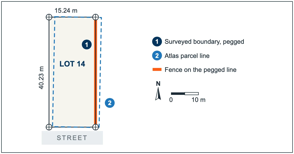
The SA Property and Planning Atlas, known as SAPPA, is the state's free online map for looking up a property in South Australia. It is the right place to find your zone, the overlays on your land, nearby survey marks and the title and plan references. It is not the place to find out exactly where your boundary is. PlanSA's own guidance on the atlas says so: only a ground survey by a licensed surveyor can determine the true position of a boundary.
This guide shows how to use SAPPA well, what the parcel line on the map really is, and when an owner planning a fence, a carport, a slab or a purchase needs a survey instead.
Key takeaways
- SAPPA is a free map from Planning and Land Use Services showing properties, Planning and Design Code zones and overlays, development applications, survey marks and land administration boundaries.
- Use it for planning questions: which zone and overlays apply, what the Code says for your address, and where the nearest survey marks are.
- The parcel lines are drawn from the state's digital cadastre. Each corner carries an accuracy grade, and where an area has not been spatially improved the line can sit off the true boundary.
- PlanSA's own guidance: "Only a ground survey conducted by a licensed surveyor can determine the true position of the boundaries."
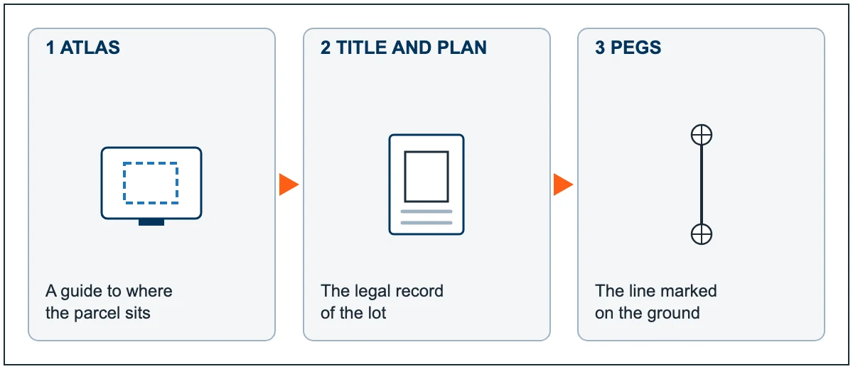
- The legal boundary is defined by the certificate of title, the registered plan and the survey marks on the ground. A boundary survey puts it back on the ground as pegs.
What SAPPA is built to show
SAPPA is a map-based web application developed by Planning and Land Use Services, part of the South Australian Government. Anyone can use it at sappa.plan.sa.gov.au. According to PlanSA's SAPPA FAQ, it brings together:
- property information, with links through to the South Australian Integrated Land Information System (SAILIS) for title details
- Planning and Design Code zoning and overlays, with a link to the Code policies for the address
- land division and land use development applications
- survey marks
- place names and land administration boundaries
For an owner, that makes it the quickest way to answer planning questions. Which zone am I in? Is there a heritage, flooding or bushfire overlay? Has the neighbour lodged a land division? Those answers come from the Code and the state's application records, and SAPPA shows them against your parcel.
Looking up your property, step by step
PlanSA's How to navigate SAPPA guide sets out the basics. In practice, a property check runs like this:
- Open SAPPA and type your address into the search bar, then pick it from the list. You can also search by other details, such as an application number.
- Right click your parcel (on a phone, press and hold for two to three seconds). The information panel shows the property data and the zoning that applies.
- Use the buttons at the bottom of the map to open the Planning and Design Code for your address, or SAILIS for title information.
- Open the layers list and switch on what you need: Code overlays, land division applications, or the Survey Marks layer. Some layers only appear once you zoom in.
- Print a report of the property data if you want a record of what you saw that day.
If you are planning to subdivide, the zone and its rules come first; our guide to the minimum block size for subdivision in Adelaide explains why there is no single figure for the whole city. If you are about to dig, the Office of the Surveyor-General asks you to check the Survey Marks layer first, because damaged marks make boundaries harder and more costly to re-establish.
Why the parcel line is not a surveyed line
The parcel outlines in SAPPA come from the state's digital cadastre: a map that joins up the corners of every parcel from registered plans so that the whole state fits on one screen. It is an index of the plans, not a survey of your land.
Every boundary corner in the cadastre carries an accuracy code from 0 to 7. Land Services SA's cadastral data page explains that improved corners have been computed from plan measurements and survey marks. The state's earlier published metadata for the same dataset (2017) adds that, outside improved areas, corner accuracy depends on the scale of the old maps the cadastre was first captured from and how they were digitised, and that a number of urban areas, mainly around Adelaide, have been spatially improved.
PlanSA's FAQ answers a question owners often ask, "Why don't the property boundaries line up with the fences?", in plain terms. The boundaries or the aerial photo may be inaccurate. Parcels in spatially improved areas generally line up better, and you can check whether yours is one by switching on the "Spatially Improved Parcel Areas" and "Integration Finished (Survey)" layers. The answer ends with this: "Only a ground survey conducted by a licensed surveyor can determine the true position of the boundaries."
The same caution applies to SAPPA's measuring tool. PlanSA's guide notes that all measurements are approximate and that the coordinates it gives are approximate only. The area the cadastre shows for a parcel is the area of its drawn shape, not a surveyed figure.
What a small gap means on the ground
On a screen, a line that sits a little off the fence looks harmless. On the ground, the same gap decides real things:
- A new fence. A fence built along the map line can end up on the neighbour's land or give some of yours away. The state's boundaries and fences guidance notes that many existing fences are not on the boundary, and that where a fence stands does not change the legal boundary.
- A carport, shed or wall on or near the boundary. How close you can build depends on where the boundary actually is. A build set out from the map, or from an old fence, can end up too close or over the line.
- A slab or extension. Pegs set from the registered plan give the builder a line to work to, instead of a line read off a screen.
- Buying a property. The atlas shows you the zone and overlays before you make an offer. It cannot tell you whether the fence, driveway or garage matches the title.
There is no standard size for the gap. It varies from parcel to parcel, which is exactly why the map cannot be used to settle it. In a spatially improved area the atlas line may sit close to the boundary; elsewhere it may not. Either way, the decision you are making needs the surveyed line.
Fence, carport or slab going in soon? Send us your address and a line about the job. We will tell you which survey you need and quote it, free.
GET A BOUNDARY SURVEY QUOTE CALL (08) 7110 0760
Rated 5.0 on Google from 17 reviews.
Where the boundary is actually recorded
The legal boundary of your land is not on a web map. It sits in three linked records:
- The certificate of title. Land Services SA describes the certificate of title as an official record of land ownership in South Australia. A copy is called a Register Search. Through SAILIS, Register Search Plus gives you the title, the plan and the registered dealings, as Land Services SA explains.
- The registered plan. Your lot is shown on a plan registered for your land, such as a deposited plan (D) or a filed plan (F); community and strata plans also exist. The plan holds the measured dimensions of the lot.
- Survey marks on the ground. Survey marks placed by licensed surveyors tie the plan to the land. In South Australia you cannot move or remove a survey mark placed by a licensed surveyor.
Only a licensed surveyor can carry out a boundary survey or place a mark that defines a boundary. The Office of the Surveyor-General notes that cadastral surveying is regulated by the Survey Act 1992. A boundary survey reads the title and plan, finds the existing marks, and pegs your corners so you can see the line.
When SAPPA is enough, and when to book a survey
| Your question | Use SAPPA? | What settles it |
|---|---|---|
| What zone and overlays apply to my block? | Yes | SAPPA and the Planning and Design Code for the address |
| Has a land division or development been lodged next door? | Yes | SAPPA application layers, then PlanSA |
| Are there survey marks near where I plan to dig? | Yes, as a first check | SAPPA Survey Marks layer, then protect the marks on site |
| Where exactly should the new fence go? | No | A boundary survey with pegs |
| Is the existing fence, wall or shed on the line? | No | An identification survey showing where structures sit against the boundary |
| How far is my planned carport or extension from the boundary? | No | A survey set out from the registered plan |
| Is the land I am buying the size the map says? | As a rough guide only | The title and registered plan, then a survey if it matters |
If a neighbour is involved, the order matters too. Our guide to the Fences Act in South Australia explains why the boundary should be pegged before a fence notice is served.
Frequently asked questions
What does SAPPA stand for?
SAPPA stands for the South Australian Property and Planning Atlas. It is a free online map from the South Australian Government's Planning and Land Use Services, used to look up properties, zones, overlays, development applications and survey marks.
Can I use SAPPA to find my property boundary?
You can use it to see roughly where your parcel sits and to find its title and plan references. You cannot use it to fix the boundary's position. PlanSA states that only a ground survey by a licensed surveyor can determine the true position of the boundaries.
Why doesn't the SAPPA line match my fence?
Either the parcel line or the aerial photo may be out, and the fence itself may not be on the boundary. Many fences are not. Parcels in spatially improved areas usually line up better. A survey shows which of the three is right.
Where can I find free property boundary maps in South Australia?
SAPPA is free and shows parcel outlines for the whole state. Treat those outlines as a guide to where a parcel is, not where its boundary lies. The title and registered plan, available through SAILIS for a fee, hold the legal dimensions.
How close can I build to my boundary in South Australia?
It depends on the zone and the Planning and Design Code rules for your parcel, which you can open from SAPPA. Because those distances depend on where your boundary actually is, a survey is the reliable way to set the building out.
Do I still need a survey if SAPPA shows my parcel?
Yes, when the job depends on where the line is: a fence, a build near the boundary or a purchase. A boundary survey pegs the line. Our price guide for residential surveys on standard-sized blocks is $800 to $3,500, depending on the type of survey and the size and complexity of the land. Send us your address for a free quote.
Before you rely on the map
- Use SAPPA for zones, overlays, applications and survey marks.
- Check whether your parcel sits in a spatially improved area, and treat the line as a guide either way.
- Get the title and plan if you need the lot's measured dimensions.
- Before a fence, wall, carport, slab or purchase that depends on the line, get the boundary pegged by a licensed surveyor.
City Surveyors Adelaide provides boundary and identification surveys across Adelaide and the Adelaide Hills.
Put the real line on the ground. Tell us the address and what you are planning. We will tell you which survey you need and send a free quote.
GET A BOUNDARY SURVEY QUOTE CALL (08) 7110 0760
Rated 5.0 on Google from 17 reviews. More about our residential surveying work.
Sources checked 19 November 2026: PlanSA, SAPPA FAQ and How to navigate SAPPA; Land Services SA, South Australian cadastral data, Get a copy of your Title and glossary; Location SA, parcel cadastre metadata (2017); Office of the Surveyor-General, cadastral surveying and survey marks; SA Government, boundaries and fences. General information only, not legal or planning advice.